Raby Castle and Estate, in the heart of County Durham, is committed to sustainability as part of its highly ambitious two-year redevelopment and restoration plan, known locally as The Rising.
The Estate has drilled two exploratory geothermal boreholes to identify whether a renewable energy source will help meet the annual heating requirements of The Rising scheme.
The Rising is the largest project undertaken at the Estate for generations and involves the restoration and repurposing of three beautiful heritage buildings in the magnificent grounds of Raby Castle, providing a unique experience for visitors. As well as the construction of two thoughtfully designed new buildings, it also includes the remodelling of the historic Walled Garden and the creation of landscaped public areas.
The project will open-up spaces that have never been seen by the public before, as well as introducing new event and exhibition spaces, retail, dining and a new visitors information centre. The first phase, the building of The Plotters’ Forest Adventure Playground and new visitor’s car park was completed in 2022, with the second phase currently ongoing.
Sustainability and futureproofing are a key focus for the Estate, and its custodian, Lord Barnard. Whilst expansion often means further demands on resources, there is a commitment to lessen the environmental impact of the development.
Raby Estate has been working closely with local specialist designers TGA Consulting Engineers, to explore renewable energy. The designer’s in-house Mechanical, Electrical and Building Performance teams have demonstrated, through in-depth analysis, that heat can be extracted from the ground via an ‘open loop’ Ground Source Heat Pump system, to provide 60% of the annual heat demand of The Rising scheme and reduce the development’s carbon emissions by 40%.
“The first stage of testing has shown extremely positive results”, says Matthew Cole, technical director at TGA Consulting Engineers. “This is an excellent and challenging project, with a lot of feasibility work on the appropriate integration of renewable energy solutions site-wide. It is hoped that the boreholes will deliver a minimum of 200kW of sustainable, low carbon thermal energy, with the opportunity to add further heat pump modules at a later date.
“The hope is to install a new district heating Ground Source Heat Pump system, to deliver heat to several buildings on the site – a valuable step towards Raby’s renewable future, and the start of Raby Estate’s net zero journey.”
“I am delighted that the initial studies have been so positive and suggest that we might have a long-term renewable energy source here at Raby Castle. Lady Barnard and I both felt it was important to pursue this and it would give me a great sense of pride to know that Raby Castle might secure a renewable future for the generations to come,” said Lord Barnard.
Further tests will be taking place over the coming months, with a final report due early in 2024.
Largest ever peatland project completed in the North Pennines
The North Pennines AONB Partnership is celebrating the completion of its largest and most complex peatland restoration project to date, as part of the Great North Bog initiative.
Raby Estates worked in partnership with the AONB team and a tenant farmer, John Bell, to complete a programme of restoration on Valance Lodge, a landholding in Upper Teesdale. The 96-hectare site was a severely eroded area of blanket bog and, if left unrestored, the damaged peat would have leached carbon into the atmosphere, contributing to further climate change.
Valance Lodge in numbers:
1190 tonnes of stone to build 928 stone dams and 1020 coir rolls used to raise the hydrology and slow the flow of rainwater from the high moors
5,738 bags of moss-rich nurse crop to protect the peat and kickstart revegetation
150 wool rolls used to trial sheep’s wool as a new material for restoration
Over 15km of eroded peat haggs re-profiled
Lime, seed and fertiliser spread over 14 hectares of bare peat
63,000 cottongrass plug plants and 63,000 sphagnum plug plants, planted by hand
90,000 sphagnum clumps harvested, chopped and spread
The North Pennines AONB Partnership has restored an area of peatland four times the size of Newcastle in the last 17 years.
This was the AONB Partnership’s first multi-year project, extending over three years, and was the largest ever in scale. The total budget of £1.2million, came from a funding package of multiple funding sources, bringing together public funding with private sector investment.
The North Pennines AONB Partnership is working with other protected landscapes and peat partnerships in the North of England, collaborating on the Great North Bog coalition.
Working at scale with multiple sources of support is central to the Great North Bog coalition’s ambitious, landscape-scale approach to upland peatland restoration and conservation. A long-term funding, restoration, and conservation plan across nearly 7000 square kilometres of peatland soils in the Northern Protected Landscapes will store 400million tonnes of carbon and will make a significant contribution to the UK’s climate and carbon sequestration targets.
The Valance Lodge site was the largest area of bare peat on the estate and the restoration work presented logistical challenges for the AONB team, the estate team, and the contractors, JW Bainbridge Contractors Ltd. Most peatland sites are difficult to access with the machinery and materials needed for restoration, but at the size of over 150 football pitches and with challenging terrain, the task was even more difficult. The bulk of the materials were airlifted in by helicopter as much of the site is inaccessible any other way.
Innovative new methods of restoration were used, alongside the tried and tested techniques that the AONB team has successfully used throughout the exposed uplands of the high North Pennines.
Tenant farmer, John Bell, was commissioned to make large rolls from his sheep’s wool, which were used to create dams to slow the flow of water from the high moorland site. John produced 150 one-metre rolls using the wool from his own fell sheep, bound with coir netting. The trial was seeking to establish if the sheep’s wool rolls can replace coir as a suitable material for use in peatland restoration. Permission was granted from the Animal and Plant Health Agency to use the wool in the trials providing it was sourced from sheep grazing the same parcel of land that the bare peat is on.
For the first time, contractors carrying out reprofiling of severely eroded peat haggs or gullies, borrowed turves from well-vegetated areas immediately adjacent to the bare peat. Once in place, these turves stop erosion immediately.
In another trial, a total of 90,000 Sphagnum moss clumps from healthy donor sites elsewhere on the estate were harvested and chopped, then spread across bare peat areas, followed by a mulch of coarser cut vegetation. Revegetation has begun successfully with this method.
Joe Robinson, our Land Agent , said: “We’re very pleased to have been part of this collaborative approach to restore such a large area of land. It’s also extremely positive that this project is part of the wider, pan-Northern collaboration for peatland restoration in the form of the Great North Bog.”
Kate Cartmell Done, Senior Peatland Field Officer for the North Pennines AONB Partnership, said: “This was an immense project to tackle, on a scale we’ve not worked on before. We’ve learned a lot from this project, and we’ve been able to use this experience and knowledge as we begin work on other larger sites across the North Pennines AONB.
“What has been a great success has been the partnership working, with the Raby Estate team, and the shooting tenant from another part of the estate, as well as John Bell, the farmer.
“Having the multi-year project also meant we were able to develop a long-term, working partnership with our brilliant contractors, JW Bainbridge. We’ve all been able to see the restoration work becoming established over the three years we’ve been on site, which really helps to demonstrate the value of this work for nature recovery and helping to tackle climate change.”
Funding for the Valance Lodge restoration came from Defra (including Countryside Stewardship and the Farming in Protected Landscapes programme), Natural England’s Nature for Climate Fund, The National Lottery Heritage Fund via the Tees-Swale programme, the EU LIFE Programme (Pennine PeatLIFE), and private sector support from Morgan Sindall Group.
Graham Edgell, Director of Procurement and Sustainability at Morgan Sindall Group remarked: “We understand the need to play a significant role in reversing habitat loss and improving the condition of our peatlands. Our partnership is an excellent example of a private sector organisation working with the conservation sector to deliver this level of landscape-scale restoration. The results to date have been outstanding and we look forward to further collaboration.”
News
World Anatomy Day – ‘dissecting’ an interesting book found in Raby’s collections
October 15th– World Anatomy day
In celebration of World Anatomy Day, we’re ‘dissecting’ an interesting book found in Raby’s collections.
Andreas Vesalius
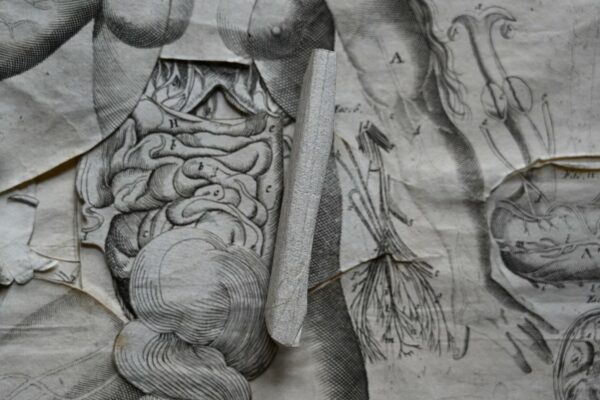
World Anatomy Day honours the work of Andreas Vesalius on the anniversary of his death in 1564. Vesalius is considered the founder of human anatomy studies, through the creation of his seven-volume book De Humani Corporis Fabrica (on the fabric of the human body.) The work dissects the human body and considers each layer separately, from bones and cartilages, to ligaments and muscles, and the heart and other organs. The information is accompanied by classical illustrations and backgrounds of Italianate landscapes.
Published in 1543, the work was paired with a companion piece called the Epitome. This contained a brief summary of the anatomical structures in the Fabrica, but more interestingly a series of woodcuts of the dissected human body. This included a sheet which could be cut up and glued together by the reader to make a layered paper manikin (a medical model of the human body.) This helped readers- often medical students- to better understand how the human body was dissected and put together.
The book in Raby’s collection is similar in use and purpose to this Epitome by Vesalius.
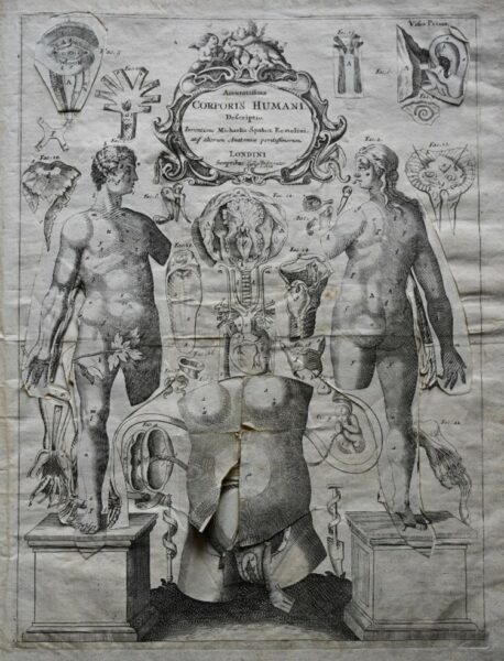
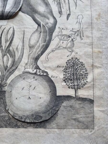
A section of the book showing the different layers of the body.
(Raby Collection)
Multi-layered anatomy
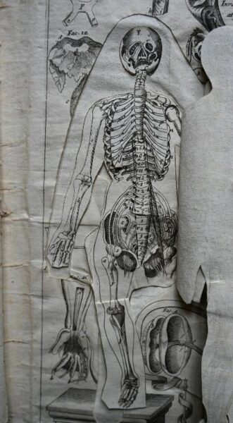
Illustrating anatomy using multi-layered flaps became popular during the sixteenth and seventeenth centuries. These were known as fugitive sheets, and were made up of engraved figures with additional sections as ‘flaps’ on different parts of the body. When lifted, these layers revealed illustrations of organs, blood vessels and bones.
This tradition began with Heinrich Vogtherr, who depicted a seated woman in 1538. A flap on the woman’s belly could be lifted to reveal her internal organs. He used the same woodblocks to create a male print a year later, changing the head and torso. Within the year, printers in other cities had created their own versions which were circulated throughout Europe.
They proved so popular that versions were created in several different languages, making specialist anatomic information more accessible to a wider audience.
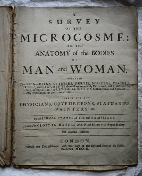
The book in the Raby collection, ‘A Survey of the Microcosm, or the Anatomy of the Bodies of Man and Woman,’ is a good example of this, being an English translation of an earlier work. The sub heading explains that the book is ‘useful for all physicians, chyurgeons, statuaries, painters,’ showing its appeal to a wider audience than just those in the medical field.
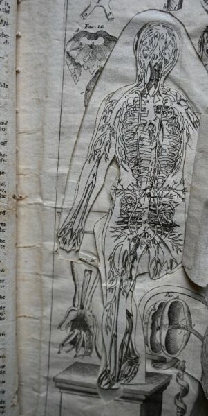
Catoptrum Microcosmicum
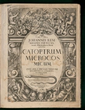
The author of the original work from Raby’s collection was Johann Remmelin (1583-1632)- Remilinus in our English language version- a German medical doctor and anatomist. His Catoptrum Microcosmicum was first published in 1619 in Latin. It went through several editions in Latin, German, French, Dutch and English.
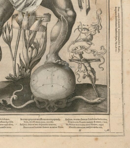
An original version of Remmelin’s Catoptrum Microcosmicum (1619) digitised by the Osler Library of Medicine.
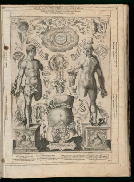
In earlier editions of the work, the background designs surrounding the anatomical figures include symbolic imagery from the Bible and classical literature, such as images of snakes, crucifixes, and a devil in front of the woman’s womb.
Our version- from nearly 90 years later in 1702- is a much simpler design, lacking illustrations and imagery, and missing text on the pillars the two figures are standing on. There are also fewer pages of accompanying text, as it was possibly for a less specialised audience.
An example of the illustrated details of the original work (left) compared to our later edition (right)
Perhaps having this book in the collection suggests that someone in the Vane family held an interest in anatomy. The wear and tear seen on some of the flaps indicates the book has been well used throughout the years.
Alan McKerchar, general manager at Raby Castle said: “I am immensely proud of our incredible team and their unwavering dedication each and every day to create a memorable experience for all of our visitors to Raby Castle. Our heartfelt thanks go to our people here at Raby – you all work tremendously hard and your enthusiasm and commitment doesn’t go unnoticed.
“Securing a nomination for the VisitEngland ‘Welcome’ Accolade was an achievement in itself, but to have now been awarded the prestigious accolade is a fantastic achievement for the team.
“2024 is going to be a significant year for us with the opening of The Rising in the spring – a visionary collective of heritage buildings brought to life and two thoughtful new constructions, offering retail, hospitality and event spaces which will make Raby an iconic destination in the area. We all feel we can now move forward with the final stages of the scheme with immense pride as recipients of this fantastic accolade.”
22nd August 2023
Raby Castle has been nominated for the prestigious VisitEngland ‘Welcome’ Accolade after our staff scored 100% in a recent assessment.
Staff across visitor services, catering and retail as well as tour guides and volunteers within the castle were awarded marks out of five for customer care, efficiency and knowledge during an annual VisitEngland Visitor Attraction Quality Scheme assessment.
The team achieved the highest possible score and were praised for their excellent levels of customer service, their professional and warm approach, as well as overall appearance.
VisitEngland’s Accolades are designed to celebrate excellence within the visitor attraction sector and showcase those businesses that go the extra mile to provide a high-quality day out.
Alan McKerchar, the general manager here at Raby Castle said: “Our people are what makes a visit to Raby such a special experience. They are everything to us and I’d like to say a huge thank you to them all for achieving such an incredible result and securing this nomination. To be awarded 100% is no mean feat and is a testament to their hard work, enthusiasm and commitment to providing our visitors such a memorable experience.”
Raby Castle has also retained the VisitEngland accreditation of a quality attraction with a score of 92% – an increase on our previous score, demonstrating the ongoing commitment to continually enhance your visitor experience.
“To have improved our overall score whilst some of the attraction is in temporary facilities during the significant development we are currently undertaking, is something to be really proud of.
“If we can achieve such a great result at this time, I can’t wait to see Raby’s score when The Rising is complete, when we hope to attract new visitors to the area and create outstanding recreation for the local community,” added Alan.
Introduced in 2014, the accolades are available to VisitEngland’s Visitor Attraction Quality Scheme participants across a wide range of tourism experiences in England from museums and galleries, farm attractions, historic houses and gardens to churches, cathedrals and country parks.
Winners of the ‘Welcome’ Visitor Attraction Accolade will be announced later in the year.
Raby Membership
With so many exciting adventures to be had at Raby Estate this season, a Raby membership is the best way to enjoy access to everything and anything Raby Estate has to offer**. The Raby membership begins from £15 per year for children from 4 to 12-years-old, £28 per adult, £25.00 per concession, with family passes starting at £80 (2 adults + 3 children), with benefits including admission to Raby Castle, the Deer Park and High Force Waterfall and 10% off at the Yurt Café, Stables Shop and High Force Hotel, in addition to access to the East Garden. A Plotters’ Forest adventure playground extension is available.
News
Climb of Life 2023
Once again a team of intrepid hikers from Raby Estates will be raising money for the Institute of Cancer Research by participating in a “Human Mountain Endeavour” on the Lakeland fells on Friday 10th November 2023.
One-third of us will be touched by cancer in our lifetime. The Institute of Cancer Research (ICR) is an academic working body based at the Royal Marsden Hospital. ICR employs over 300 scientists and has taken more drugs into clinical trials in the last decade than any other organisation worldwide. We are therefore proud to be supporting such a worthy cause again this year.
This annual event involves teams from businesses located across the north of England ascending Lakeland’s highest mountains in early winter conditions. The event has raised more than £1.75 million for the Institute and other charities over the past 34 years. With your help, we would like to make this another record-breaking year.
Last year a team of 12 walkers from Raby successfully completed a trek in the fells around High Street and raised around £7000. This year the Raby Estates Team will be tackling Helvellyn, one of the most iconic and majestic peaks in the Lake District National Park of England. Standing at 950 meters above sea level, it is renowned for its breath-taking beauty and challenging hiking trails. It’ll be a long day in the hills.
If you would like to support our team with their fundraising for Climb of Life, and the motivation to complete this arduous challenge, then please go to their JustGiving page to donate.
2023 Update
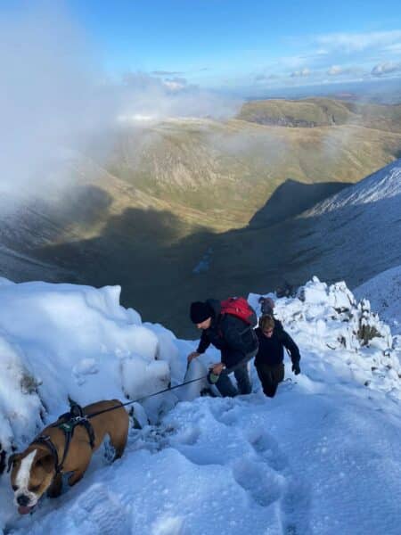
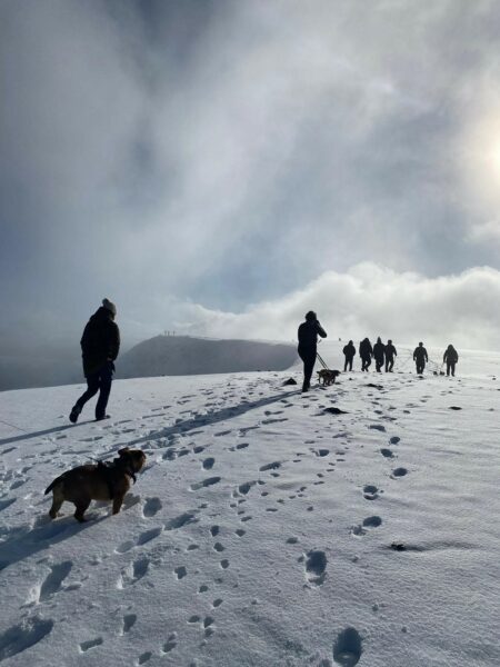
Many thanks indeed for your generous support for this year’s ICR Climb of Life Appeal. 12 climbers and numerous dogs made up the Raby team having been assigned Helvellyn as our challenge this year.
We were blessed with a magical day and snow-covered fells as we made our ascent from Glenridding at the southern end of Ullswater. On reaching Red Tarn we rested and contemplated the final climb onto the summit via a snow covered Swirrel Edge. There were a few hairy moments as dogs of various sizes were cajoled over the more exposed parts of the ridge. Thankfully, we reached the summit unscathed with the team and assorted canines intact to enjoy some magnificent views in the early winter sunshine.
This year’s event raised just over £71,000 overall for ICR and I am pleased to confirm that we made one of the largest single team contributions of £6,000.
This year’s grand total means that this annual event has now raised over £1.70 million during the 34 years that it has been taking place with over £1 million raised for Institute of Cancer Research during that period. This of course would not have been possible without your generous support. All of us at Raby are therefore enormously grateful to you. Many thanks once again for your support and your donation.
News
Slow Cooker Raby Venison Osso Bucco
Prep Time 30 min | Cook Time 8hours | Serves 4
Ingredients
1kg Venison on Bone
75g Plain Flour
1/2 teaspoon Salt
¼ teaspoon Black Pepper
2 tablespoons Oil
1 Chopped Onion
2 Chopped Carrot
2 Chopped Celery Stalks
1 tablespoon Crushed Garlic
125ml Red Wine
1 teaspoon Sugar
1 teaspoon Thyme
800g Chopped Tinned Tomato
20g Tomato Paste
1 Bay Leaf
125ml Beef Stock
1 teaspoon Dried Thyme
1 teaspoon Dried Basil
1 teaspoon Dried Parsley
Method
In a bowl, add the flour and mix with the salt and pepper.
Coat each slice of the beef shank in the flour mixt.
In a frying pan over medium heat, add the oil.
Cook the beef in batches. Cook until each side is browned (Roughly 3-5 minutes).
In a slow cooker, add the onion, carrot, celery, garlic, red wine, sugar, thyme, diced tomatoes, tomato paste, bay leaf, and beef stock and herbs. Mix until combined.
Add the Venison shanks so that they’re covered with the sauce.
Cook on low for 8 hours or until the meat is tender.
Season to taste. If needed add corn flour and water to the mixture to thicken.
Recipe by Estate Chef Tom Parry
News
An Autumn to Remember
Autumn is a beautiful time to enjoy a visit to Raby. The strong seasonal colours of reds, oranges, yellows and browns can be seen in splendour around our circular waterfall trail at High Force and the Deer Park at Raby Castle. With that slight nip in the air, Autumn is the perfect time to cosy up with a book or wrap up in your favourite scarf and head out for a walk. As the seasons shift there will also be some exciting displays on the wildlife calendar to watch out for across the Park.
Here are our top things to look out for this Autumn across the Estate:
Autumn Colours
September, October and November are a beautiful time to experience Raby in its full autumnal glory. Enjoy a walk around the Deer Park at Raby Castle and see the seasonal shift of the leaves as they turn to browns and golds. Or pull on your walking boots and explore our circular route at High Force to experience the bursts of colour on your way to the waterfall, a brilliant contrast against our conifer trees. Pick up a pinecone or a leaf to take home as a keepsake of your visit. After the lightness and brightness of Summer, Autumn really brings the landscape to life through its bold dark colours, nature’s final hurrah before Winter.
(c) Simon Saunders
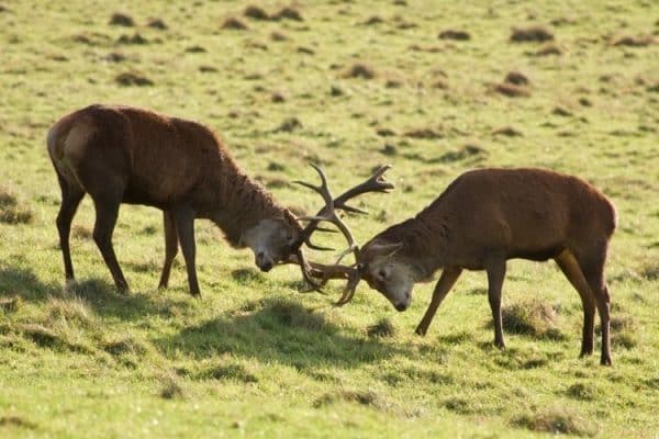
Deer Rutting Season
The rutting season, or ‘the rut’ is part of the deer’s annual cycle at Raby. Every Autumn the males compete for the attention of females by putting on an impressive display. People come from miles around to see and hear the incredible clash of antlers and the roar as the males make their challenge. We do please ask visitors not to approach the deer during this time, but you can still see the spectacle from a safe distance so bring your binoculars!
(c) Peter Gunton
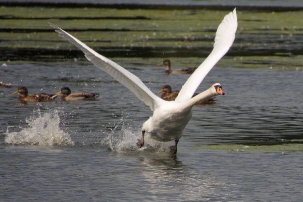
Migration and Hibernation
As the weather turns colder, birds across the Estate will start their migration to warmer climates for the Winter season. Swallows will depart our shores and make their way south, as other birds are gearing up to do the same. In Autumn fieldfare, redwing and bramblings will make their way from the cold climates of Scandinavia and Russia to the relative warmth of the UK. The striking red berries of hawthorn and rowan provide food for these Winter visitors. You might spot squirrels gathering their supplies for the long months ahead too. Keep your eyes peeled along the River Tees and you might be lucky enough to see a salmon journeying in from the Atlantic Ocean making the perilous journey upstream to its spawning grounds.
(c) Peter Gunton
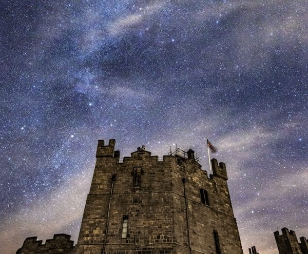
Stargazing
We are incredibly lucky in the North Pennines to have a large number of Dark Sky Discovery Sites including at Cow Green Reservoir and Low Force Waterfall, ideal locations to see the stars. Our High Force Hotel runs Stargazing Suppers throughout the Autumn months where visitors can enjoy a three-course meal followed by a guided stargazing experience. Visit our What’s On page to see upcoming dates. Or why not download an app for your own evening of discovery? Learning to read the stars is an incredible skill that can aid navigation and tell you more about our universe. Or simply go out to enjoy the peaceful spectacle of the constellations above you. If you’re lucky you may even get to witness the Northern Lights which can occasionally be seen from the North Pennines. Find out where your nearest Dark Sky Discovery Site is.
(c) Gary Lintern
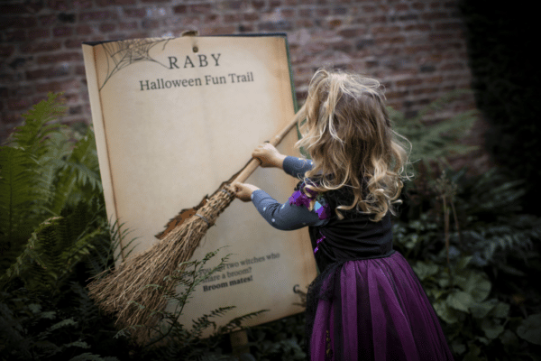
Halloween
We love Halloween at Raby. This October Half Term The Plotters’ Forest will be ghoulishly dressed for an exciting spooky trail. You might spy our woodland sculptures hiding round a corner so beware of scary spiders and our wicked witch. This year we’re inviting families to bring their carved pumpkins to Raby to be displayed around the gardens, so get your creative hat on! We can’t wait to see your designs. If you’re feeling extra brave, come along to our After Dark event and experience the trail at night.
Water Levels
The rising water levels with increased rainfall during Autumn will add to the spectacular sights of Cauldron Snout and High and Low Force Waterfall. This time of year is when High Force is at its most powerful, flowing with tremendous speed before plunging 21 metres into the pool beneath. If we have had a prolonged period of severe cold, you might even see it freeze!
Fall Flavours
As the weather gets colder we will be phasing out our Summer salads and staples in place of an Autumn palette at High Force Hotel and our Yurt Cafe at Raby Castle. Cosy up with a delicious hot chocolate or pick from our selection of warming dishes. Our Yurt Cafe will be serving a mouth-watering selection of jacket potatoes, quiche and frittatas this year. Vegan, vegetarian and gluten-free options are available too, just ask our friendly staff to advise.
Autumn Shopping
Our Stables Shop will be enjoying a refresh this season and will have a beautiful array of new items on display. From books and boardgames to homeware, blankets, local produce and children’s games, there is plenty to browse. If you’re looking to fit in some early festive shopping, we will be launching our Christmas items on Thursday 3rd November 2022 with a special shopping evening with mulled wine and possibly a visit from Father Christmas himself!
In celebration of World Pharmacists Day, we’ll be looking at an interesting item which was found nestled in the back of one of Raby Castle’s many cupboards, shedding light on the way that sickness and injuries were treated in historic country houses.
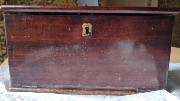
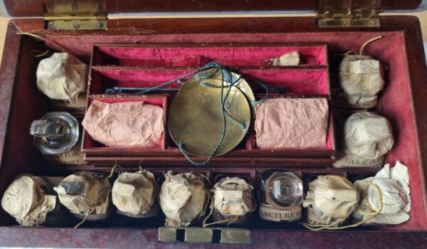
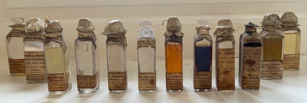
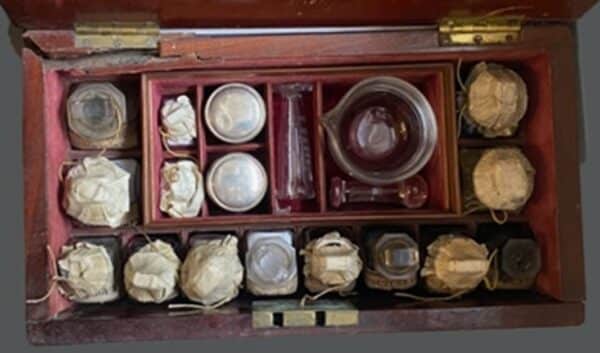
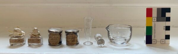
An unexpected discovery was made over the winter period at the castle, as Raby’s Curation and Archives team were busy auditing the collections while the castle was closed. A cupboard drawer was opened one day, and an unassuming wooden box was spotted. Upon opening, it turned out this box in fact contained a fascinating at-home medical collection. This included a selection of medicines- some liquid in glass bottles, other in powder and pill form- some weighing scales and measures, and a glass pestle and mortar.
What followed was a concerted effort to catalogue, research and conserve the item, so it could be preserved and understood for future use.
Research
Britain has a long tradition of self-medicating, from growing herb gardens since the time of the Romans, to medical knowledge being passed down through family recipes, and owning these medicine chests which could be described as historic ‘first-aid kits.’
Medicine chests reflect a period of change, as towards the end of the 1700s medical texts began to be written in a language the general public could understand, and readymade tinctures (a medicine made by dissolving something in alcohol) and powders made medicine more accessible and affordable. Once bottles were empty, they would be refilled and re-labelled by a pharmacist.
The chests also contained tools used to self-medicate. This included scales, a set of apothecary weights in units such as drams and grains, and a pestle and mortar to grind ingredients.
Some contained instruction manuals which explained how the ingredients should be used and in what doses. Unfortunately, ours didn’t come with an instruction manual, but pharmacist John Savory created a helpful one with detailed instructions for many of the medicines found in our box.
Savory and Moore
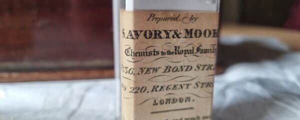
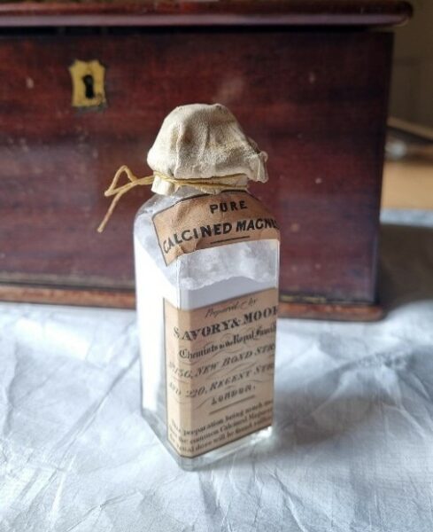
The glass bottles in our medicine box have labels for Savory & Moore or Savory, Moore & Sons. Savory and Moore were a pharmacy company, founded by Thomas Paytherus in 1794. Thomas Savory joined the company in 1797, and in 1806 he became partners with (another) Thomas Moore.
They were originally based at 136 New Bond Street, then 143 Bond Street from around 1840, (it could be that 136 was re-named 143 Bond Street) which helps us when trying to date the bottles in our collection- these are labelled as 136 New Bond Street and 220 Regent Street. A network of pharmacies was created from 1849 onwards, which could explain the additional address. Savory and Moore became the official suppliers of the War Office and the Royal Family, also seen on the label.
In 1968 the shop was closed, and the fittings and contents were given over to the Wellcome Institute for the History of Medicine. In 1992 Savory and Moore was taken over by Lloyds Pharmacy.
Medicines
The Raby chest contains some interesting medicines which tell us a bit about health and society during the mid-to-late 1800s. These include:
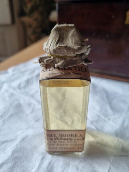
Sal Volatile: Smelling Salts
Found in everyone’s medicine box during the Victorian period, smelling salts were used as a stimulant to restore consciousness after fainting.
Purgatives
It was popular throughout the 19th century to induce sweating, vomiting or diarrhoea as a means of treating several illnesses- to ‘purge’ the body. This was done using several remedies in the medicine chest.
Rhubarb, specifically the root of Turkey Rhubarb, was used as a strong laxative. John Savory, in his ‘Companion to the Medicine Chest’ in 1836, states ‘the medicinal properties of this valuable root are so well known, that it appears to almost a work of supererogation to mention them. It is administered in the forms of powder, infusion, and tincture.’
He also suggests Senna as a ‘very useful and very general purgative, there being scarcely any disease in which it cannot be administered. It is customary to disguise the nauseous taste of senna…’
Familiar: Castor Oil
There are some names, such as Carbonate of Soda and Castor Oil, which it wouldn’t be unusual to see in a kitchen cupboard today. Savory talks of cold drawn Castor Oil “This oil is a valuable aperient; for whilst, in doses of from half an ounce to an ounce, it thoroughly evacuates the bowels, it does so with little irritation; hence it is especially useful in inflammatory cases… One disadvantage attending the use of this oil is its tendency to excite vomiting, but this is counteracted by combining it with some aromatic… Upon the whole, castor oil is a purgative of great value.”
Unfamiliar: James’s Powder
James’s Powder, or ‘Dr. James’s Fever Powder’, was one of the most successful patented medicines from the mid-eighteenth century to the early twentieth century. The medicine claimed to ‘cure most complaints that are not mortal, or chronical’. Several attempts were made to understand the formula, and it was believed to have contained antimony- once used to induce vomiting, but now known to be poisonous- and calcium phosphate. It was never proven effective and is now considered a form of ‘quackery.’
Conservation
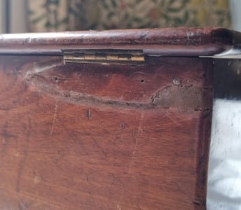
The box was then handed over to our Conservation Placement Student. Davina’s first step was to create a conservation proposal, which included a thorough object description, detailing the materials involved. This item was interesting to a conservator because the range of materials there were to work on, such as the rosewood box, copper alloy hinges and handle, textile lining and glass bottles with leather lids.
She then assessed the condition of the item: the box exterior had a break in the wood with evidence of historic repair, the interior fabric was dirty, and some corrosion was present in the metal. There was also the risk of potentially hazardous substances to consider.
Finally, Davina offered her proposed conservation treatments and got to work. She surface cleaned the contents, such as the glass bottles and measuring equipment, and removed the historic adhesive from the broken section of the medicine box. Using a sympathetic adhesive, she mended the break before adding pigments to colour match the mend with the item.
Cataloguing
Our Collections Intern, Rebecca, was then responsible for photographing and recording the item before adding it to our Collections Management System. This would enable us to locate the item in the future once it was safely packed away, if we wanted to use it for a display, talk or further research.
Archives
Research into the chest was supported by documents found in the castle’s archives. As previously mentioned, medical remedies were passed down through families. In the Raby collection we have a series of receipt books, which often had food recipes on one side and medical recipes on the other.
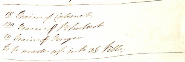
One recipe in ‘Mrs. Vane’s Receipt Book’ instructs the reader how to make Rhubarb calomel pills:
18 grains of Calomel
130 grains of Rhubarb
10 grains of Ginger
To be made into 36 pills.
These could easily be produced with some of the contents of the medicine box. (Do not try this at home!)
Thanks to the meticulous photography of our Collections Intern, we were able to research the history of the item more easily. With the work of our Conservation Placement Student, we have ensured the item can be preserved safely for many years to come, and with the collaboration of our Archivist, we can better understand how the item would have been used in the context of the family. A real team effort!
News
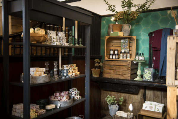
Bookings Open at Raby Castle’s New Event Spaces
The Rising development has marked a momentous milestone, as bookings for 2024 events open in its magnificent new events spaces. The iconic spaces will welcome guests to enjoy unique events opportunities in the stunning historical surroundings.
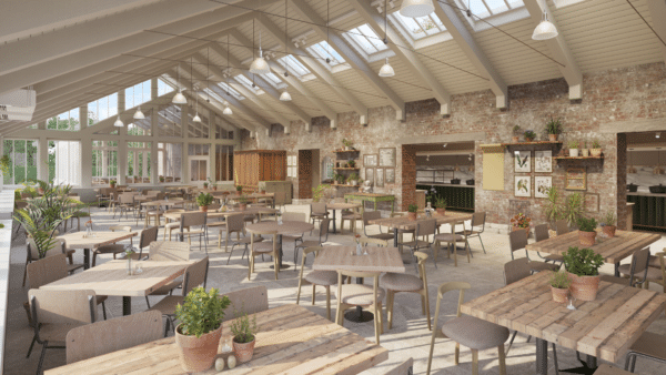
The Rising project has seen the restoration and repurposing of two heritage buildings, just beyond the Castle walls, known as the Dutch Barn and Riding School, as well as the remodelling of the Walled Garden and the commencement of work on the newly created Vinery Café Restaurant.
The new spaces will be the ideal location to host events of all sizes, from product launches to fashion shows, exhibitions and market-style fairs. Unlike a hotel or traditional conference venue, each individual setting will offer the exclusive combination of heritage, character and energy, in Raby’s beautiful parkland setting.
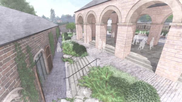
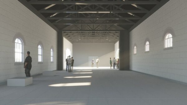
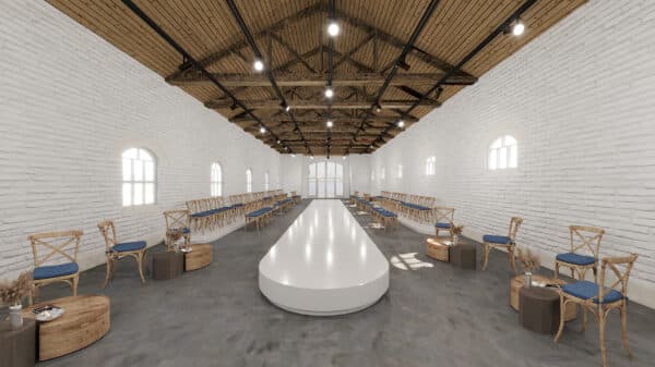
Across the project, structural work has been completed on Raby’s best-kept secret, the Grade II* listed Dutch Barn, an iconic piece of architecture, which has been hidden for decades now becoming an unmatched venue for all kinds of special events.
During the works, though the structure of the open-sided barn was secure, stone repairs were needed throughout the elegant agricultural building, as well as repairs to the exposed beams and timbers.
As with the rest of the project, where possible, the original timber has been saved and reused, with new timber blending sympathetically with the old, while maintaining the structural integrity. The completed space offers an arcaded building, providing an elegant, covered venue for a multitude of different events.
Work is currently underway on the neighbouring Riding School. The extraordinary space was once used to showcase Raby’s illustrious equine past and sits adjacent to the Victorian Coach House.
Horses and their riders would have traditionally entered the 66-metre-long space via the east entrance through double height doors. Though the original doors will remain in situ, the expansive, unrestricted space, which will hold over 400 people, will now benefit from two new entrances and the main entry point will be moved to the north/south verticals, creating a straight line for visitors to follow from the remodelled Walled Garden, through the Coach House, into the Riding School and on to the Dutch Barn.
These areas will be symmetrically linked with stairs and adjoining ramps traversing the newly installed Duchess’s Walk, a beautifully landscaped area for quiet reflection in this busy destination.
Visitors will also benefit from a stylish new dining opportunity, the Vinery Café Restaurant a stylish and airy recreation of the historic glass house which once stood on the same spot, offering seasonal and locally sourced food with stunning panoramic views of the castle on the horizon. The restaurant will seat over 200 guests, ideal for leisurely brunches, meetings and celebratory dinners.
“We are delighted to announce the opening of bookings in our extraordinary new event spaces,” says Sophie Brown, events manager at Raby Estates. “The Dutch Barn, Riding School and Vinery Café Restaurant are three of the most iconic buildings on the Raby Estate, each with its own character, offering exceptional spaces for all kinds of special events, which cannot be found elsewhere.
“Guests will be able to soak up Raby’s unique and unspoilt heritage, in our spectacular new spaces, each with its own individual charm. Due to the size and scale of our offering, we are able to accommodate events of any size and nature.
“We feel these characterful settings will reflect our distinctive and simple ambition – to offer unexpected elegance, thoughtful design and fresh, local food, in an unparalleled heritage setting, making the most memorable events experience”, concludes Sophie.
To enquire about bookings at Raby Castle, please visit: https://www.raby.co.uk/raby-castle/corporate-events/
For further information on The Rising, please visit: www.raby.co.uk/about-us/development/raby-castle-development/
CGIs: Artistic license, image for illustrative purposes
News
Barnard Castle project welcomes their Royal Highnesses the Duke and Duchess of Gloucester to Raby Castle
Royal Highnesses, The Duke of Gloucester and Duchess of Gloucester visited County Durham, this week (13th September), to recognise the region’s longstanding commitment to traditional skills training and heritage restoration.
As patron of the Cultura Trust, the national charity which has supported sustainable development and traditional values across cultural town and landscape development for over 50 years, The Duke of Gloucester, accompanied by his wife, The Duchess of Gloucester, spent time at Raby Castle as part of their day in the northeast.
Cultura Trust is currently leading a partnership between four leading organisations (Raby Estate, Durham County Council, English Heritage and the charity), to transform and secure the future of the castle at Barnard Castle, with plans to open up the outer ward and provide a new visitor centre and learning resource in the Market Place.
Raby Estates previously acquired a property in Barnard Castle’s Market Place, which formerly housed a NatWest bank branch. Currently undergoing repairs, the building will offer a great opportunity to link the marketplace and castle precinct. The inner ward of the castle, also owned by Raby Estates and managed by English Heritage under a Guardianship Agreement, is open to the public, and the hope is that the outer ward will also be reinstated for community use.
Both Cultura Trust and Raby Estates are providing continued support for the preservation of the region’s cultural heritage buildings, whilst also ensuring young people are learning the tools they need to succeed in a career in restoration and conservation.
Welcomed by Graham Bell, Cultura Trust’s director, and Raby Estates’ custodians, Lord and Lady Barnard, at Raby Castle, Their Royal Highnesses, The Duke and Duchess of Gloucester, began their visit with a presentation from a team of Croatian stonemasons, currently on a working visit to the UK organised by Cultura Trust.
“It was an honour to welcome Cultura Trust’s Patron, HRH The Duke of Gloucester, and HRH The Duchess of Gloucester, to County Durham today. This visit was a unique opportunity to introduce them to the Trust’s partners, locally and internationally”, said Mr Bell.
“HRH The Duke of Gloucester trained as an architect, so the visit focused on the value and ‘international language’ of traditional skills held in common by Cultura, Raby Estates, and trainers and students from the Stonemasonry School of Croatia.”
In addition, the visit also included a presentation from Historic England’s geospatial team and members of English Heritage’s conservation team, showcasing the newly created 3D resources being used for conservation and tour interpretation of the castle at Barnard Castle.
Following lunch, their Royal Highnesses were escorted around Raby Castle’s landmark development The Rising, currently under construction in the grounds of the iconic castle.
The ambitious renovation and restoration scheme will provide hospitality, event and retail space outside the 700-year-old castle walls, for the whole community to enjoy. The tour around the 24 acre development, culminated in a walk around the recently completed eastern section of the historic Walled Garden, a beautiful garden for quiet contemplation crafted by Lady Barnard and world-renowned landscape designer Luciano Giubbilei.
Work in the garden, just a stone’s throw from the 14th century castle, has included extensive planting, the introduction of topiary elements and the creation of a unique tiered grass amphitheatre.
Lord Barnard said of the visit: “As we move into the second year of The Rising development, we are proud to showcase Raby’s investment in heritage crafts and skills training to Their Royal Highnesses The Duke and Duchess of Gloucester. The Rising is a highly ambitious project, establishing a new tourism destination in the north of England, embracing and celebrating the restoration and conservation of our historical buildings.
“As part of our investment in the community, we are committed to providing continued training to revive past heritage crafts used in sustainable restoration, upholding the past, whilst embracing the best aspects of the present and future.”